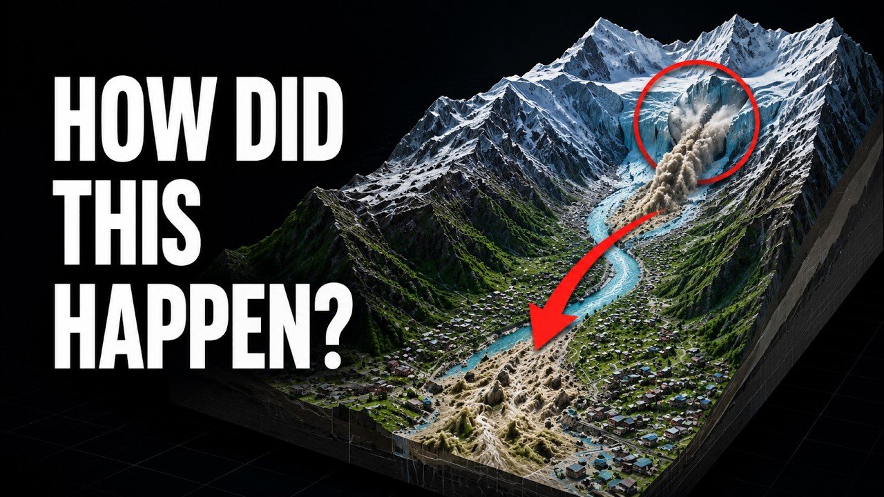
On August 26, 2026, a sudden collapse of ice and rock high in the Himalayas triggered a devastating chain reaction that sent water, mud and debris through communities along the Nepal–Tibet corridor. What initially appeared to be an earthquake-related disaster later became a much more complicated story involving a collapsing glacier, a temporary river blockage and a powerful debris flow.
The disaster has raised difficult questions about Himalayan hazards, early-warning systems and the growing challenge of protecting communities that live downstream from rapidly changing mountain environments.
According to the source material for this report, the event affected areas on both sides of the Nepal–Tibet border, including the Gyirong area in Tibet and settlements around Timure and Syapru Besi in Nepal’s Rasuwa district.
What Happened in the Himalayas?
The disaster began high above the Nepal–Tibet border.
A large section of ice, rock and mountain debris suddenly broke away and plunged into a narrow river valley. The enormous collapse struck the river and temporarily blocked its flow.
For a short period, water began accumulating behind the natural blockage.
Then the blockage failed.
The result was a sudden downstream surge carrying a dangerous mixture of water, ice, mud, sediment and shattered rock. Instead of behaving like an ordinary river flood, the flow became increasingly destructive as it picked up additional material from the valley.
This distinction is important because the disaster was not simply a case of heavy rainfall causing a river to overflow. It was a chain reaction that began high on the mountain and rapidly transformed as it moved downstream.
Why Was the Disaster Initially Linked to an Earthquake?
One of the most interesting parts of the event was the confusion over what caused the initial collapse.
Early reports suggested that an earthquake had triggered an avalanche or mountain collapse.
The United States Geological Survey initially recorded what appeared to be a magnitude 4.4 earthquake near the border. This led to a straightforward explanation: an earthquake happened first, the mountain collapsed afterward, and the resulting material caused the flood.
But subsequent analysis changed that interpretation.
Scientists concluded that the seismic signal may have been produced by the collapse itself.
When an enormous amount of ice, rock and debris crashes down a mountain, the impact can generate powerful vibrations that are detected by seismic instruments. In other words, what looked like an earthquake on monitoring equipment may actually have been the physical impact of the mountain collapse.
The event was later associated with a seismic magnitude of approximately 5.2, according to the source material, but it was not considered a conventional tectonic earthquake.
The distinction is critical.
The mountain did not necessarily fall because the ground shook. The collapse itself produced the shaking.
Was This a Glacial Lake Outburst Flood?
Another early explanation described the event as a glacial lake outburst flood, or GLOF.
GLOFs occur when water stored behind a natural glacial dam suddenly escapes, potentially sending a large flood downstream.
However, the source material states that available scientific analysis had not confirmed that a pre-existing glacial lake burst during this particular disaster. A stronger explanation was that the glacier collapse entered the river, temporarily blocked its flow and then produced a major surge when that blockage broke apart.
That difference matters because it changes how scientists understand the hazard.
A classic GLOF involves a lake that can potentially be monitored over time. Scientists can examine its size, water level and surrounding dam.
A sudden mountain or glacier collapse is much harder to predict.
A slope can appear stable for a very long time and then fail within seconds.
Where Did the Flood Go?
The disaster struck an important Himalayan transportation corridor.
The first heavily affected locations included the Gyirong border area on the Tibetan side and communities in Nepal’s Rasuwa district, particularly around Timure and Syapru Besi.
Buildings were buried beneath mud, roads were damaged and bridges were swept away.
The route is important because it connects communities, transport workers, border officials, travelers and people traveling toward the Kailash–Mansarovar region.
What is normally a busy mountain corridor suddenly became the route of a rapidly moving disaster.
The flow then continued through the river system, moving from the Lhende Khola into the Bhotekoshi and toward the Trishuli system.
The source material reports that the Trishuli rose by as much as nine meters in approximately 30 minutes in some areas.
That gives an indication of how quickly conditions could change.
For people living close to the river, there may have been very little time between recognizing something was wrong and facing dangerous flood conditions.
Why Did the Flood Become So Destructive?
The answer lies partly in the difference between floodwater and a debris flow.
A normal river carries water, sediment and smaller amounts of material.
But when a powerful surge begins cutting into loose sediment, fractured rock and debris along a mountain valley, it can become much denser.
The result is a mixture capable of moving enormous quantities of material downstream.
The source describes the difference simply: ordinary water can push a vehicle or damage a bridge, while a debris flow can bury vehicles and remove entire structures along with sections of road.
This helps explain why infrastructure damage was so extensive.
The disaster was not just water moving through the valley.
It was a moving mixture of water, mud, ice, rock and sediment.
Destruction Around Syapru Besi and the Border Region
Satellite imagery reportedly showed extensive changes before and after the event.
Large portions of Syapru Besi were covered by mud, while buildings and roads disappeared beneath accumulated debris.
On the Chinese side, the source material reports that mud around the Gyirong border port reached an average depth of more than 1.5 meters, with some sections reportedly covered by more than two meters.
Nepali officials reportedly said that at least 19 bridges and approximately 40 kilometers of roads were destroyed or damaged.
The consequences went beyond transportation.
When roads and bridges disappear, rescue teams may struggle to reach isolated communities. Medical supplies become harder to deliver. Food and drinking water can become difficult to transport. Communication can also be disrupted.
In a mountainous region, infrastructure damage can therefore become a second emergency after the initial flood.
How Fast Was the Disaster Moving?
One estimate cited in the source material put the ice-and-rock flow at approximately 50 meters per second, with the flow traveling more than 20 kilometers.
At that speed, the disaster could move through a valley extremely quickly.
This is one reason sudden mountain hazards are so difficult to manage.
People downstream may understand that something is happening only after the dangerous flow has already entered their valley.
Unlike a slow-moving hazard, there may not be enough time to evacuate large numbers of people once the main surge begins.
The Human Cost
The human toll remained uncertain as rescue teams entered the affected areas.
The source material reports that by August 27, at least 359 deaths had been confirmed across Nepal and Tibet, while more than 1,300 people were missing.
These figures were described as provisional.
That qualification is especially important in a disaster where roads have been destroyed, settlements have been buried and entire areas may be temporarily inaccessible. Some missing people could still be alive but unreachable, while others may have been carried far downstream.
The disaster also affected children and essential services.
The United Nations reportedly estimated that at least 17,000 children were affected in Rasuwa, Nuwakot and Dhading. Homes, schools, health centers, water systems and communications infrastructure were damaged.
Emergency assistance included funding, medical supplies, tents, helicopters and search-and-rescue operations.
A Second Danger Was Developing Upstream
Perhaps one of the most concerning aspects of the disaster was that the first flood may not have been the end of the danger.
New debris blockages were reportedly forming in the river system.
Water continued to build behind them, creating the possibility of another sudden release.
One warning mentioned approximately three million cubic meters of water potentially entering an already dammed lake on the Chinese side—an amount the source compares with roughly 1,200 Olympic-sized swimming pools.
This created a frightening scenario.
People who had survived the first wave could potentially face another flood.
Rescue workers themselves could also be placed in danger while operating in unstable valleys.
This demonstrates why mountain disasters cannot always be treated as a single event. A landslide, glacier collapse or river blockage can create new hazards that continue developing after the initial disaster.
Why Early-Warning Systems Have Limitations
The Nepal disaster also highlights a major problem with modern disaster monitoring.
Large glacial lakes can often be monitored.
Satellites can measure their surface area. Scientists can track changes over time. Dams and surrounding terrain can sometimes be inspected.
But mountain slopes are different.
A slope can remain apparently stable for years or centuries before suddenly collapsing.
There may be no obvious warning that tells authorities exactly when the failure is about to happen.
That creates a difficult challenge for early-warning systems.
A system designed primarily to detect rising water may not be able to provide sufficient warning for a sudden ice-and-rock collapse occurring upstream.
Why International Cooperation Matters
There is another important dimension to this disaster: the river crosses an international border.
Communities downstream in Nepal can be directly affected by events occurring upstream in Tibet.
That means information about river levels, landslides, glacier conditions and sudden blockages needs to move quickly between different authorities.
The source material argues that real-time hazard information may not always cross the border quickly enough, creating an additional challenge for downstream communities.
For someone living near a river, even a few extra minutes can matter.
A warning can allow people to move toward higher ground, evacuate vulnerable buildings or stop travelers from entering dangerous sections of a valley.
That is why satellite monitoring, river gauges, communication systems and cooperation between neighboring countries can all play important roles.
Did Climate Change Cause the Disaster?
This question requires caution.
It would be premature to say that climate change directly caused this particular glacier collapse without sufficient evidence.
The source material specifically emphasizes that scientists need more information before making such a conclusion.
However, climate change is altering high-mountain environments.
Glaciers are retreating in many regions. Permafrost can weaken as temperatures rise. Meltwater can enter cracks in rock, while repeated freezing and thawing can contribute to changes in mountain stability.
These processes do not mean that every landslide, glacier collapse or flood is caused by climate change.
Instead, they can change the background conditions under which extreme mountain events occur.
That distinction is important for responsible reporting.
Rather than claiming that climate change directly caused this disaster, scientists need to examine whether long-term environmental changes altered the stability of the mountain system or increased the potential consequences.
What Makes This Disaster Different?
The Nepal floods of 2026 demonstrate how several hazards can combine into one event.
The sequence described in the source material can be summarized as:
Mountain collapse → river blockage → water accumulation → blockage failure → flood surge → debris flow → infrastructure destruction → rescue difficulties → additional upstream hazards
Each stage made the next stage potentially more dangerous.
The initial collapse happened high in the mountains.
The river transformed the impact into a downstream flood.
The flood picked up sediment and rock.
The debris flow destroyed roads and bridges.
The destruction then made rescue operations more difficult.
Meanwhile, new blockages created the possibility of another wave.
That is why describing the event simply as a “flash flood” may not tell the whole story.
The Bigger Lesson for the Himalayas
The central lesson is that Himalayan hazards do not always provide a long warning period.
A large glacial lake may be visible from satellites for years.
A river gauge can detect rising water.
A weather system can sometimes be tracked before a major storm.
But a mountain slope can fail suddenly.
The source material describes the disaster as a chain reaction involving ice, rock, water, rivers, roads, borders and human settlements.
That complexity makes prevention extremely difficult.
The goal therefore cannot simply be to predict every collapse.
It must also be to make communities more resilient when prediction fails.
Better satellite observation, more river gauges, stronger communication networks, evacuation planning and faster cross-border information sharing could all help reduce future losses.
Final Thoughts
The Nepal floods of 2026 were not simply the result of a river overflowing.
According to the evidence summarized in the source material, the disaster began with a sudden collapse of ice and rock high in the Himalayas. The collapse blocked a river, water accumulated behind the temporary barrier, and its eventual failure released a powerful surge that became increasingly destructive as it carried mud, sediment and rock downstream.
The event also showed why early explanations can change as scientists gather more evidence.
What initially looked like an earthquake-triggered disaster became a much more complicated story in which the collapse itself appears to have generated the seismic signal.
And while climate change may be relevant to the changing conditions of Himalayan glaciers and mountain slopes, directly blaming it for this specific collapse would be premature without further scientific evidence.
The most important lesson may be the simplest:
In the Himalayas, the greatest danger may not always be the water you can see. Sometimes it begins high above the valley, where a mountain can change in seconds.
The scientific investigation, search operations and recovery efforts will continue, and some details—including the final human toll and the exact physical sequence of the collapse—may take months to establish with confidence.